 |
| Before there ever existed the country of Brazil or any other country, there was the land. Map I |
This article was originally thought to assist travel agents
Brazil, the largest country in South America has a
population of around 211 million people, is the fifth largest country in the
world right after the US, Canada, China and Russia and is divided into 26 states plus the Federal District
around Brasília. The country boasts 5.700 municipalities (cities) of which 2.694
are considered to have something of interest to tourists (National, International or regional ). They are subdivided into
333 tourism regions according to the Tourism Map of Brazil issued in 2019 by
the Ministry of Tourism.
But suppose you are a travel agent or an independent traveler
from anywhere in the world, how do you sort these confusing numbers and make
your way through all these seemingly conflicting information when all you want is to find
a perfect beach, a waterfall, see wildlife, meet nice people when you finally make
it to the country?
My suggestion is that we begin from the beginning. It is
almost a biblical thing. Before anything happened on Earth, before man, animals,
plants, water and waterfalls God created the Earth, preparing it to be the place where life
would occur much much later on. That includes includes You.
So the first thing I do is to show you a clean, empty outline map
of Brazil to represent the idea that
before there was a Republic of Brazil there was the land where nature so profusely
created all the species and varieties of fish, monkeys, plants, ants, animals,
palm trees, giant trees, rivers, large rivers, streams, waterfalls of all
kinds, beaches, forests, jungles, arid forests and so on.
Later, again much, much later men and women came to be. Hundreds of
native tribes and peoples all the way to the day when Europeans, Asians and
people from all over came to "The Land to create present-day Brazil.
To begin with, Nature created, before allowing Brazil to be, a big nearly undescribable JUNGLE, the Amazon Jungle up in the
North. It covers more than 50% of Brazil's landmass and spills over to neighboring countries: Bolivia,Peru,Colombia,Venezuela, Ecuador, Guyana, Surinam and France - yes France is a neighboring country, owner of the full-flegded Overseas Department of Guyane, known as French Guyana.
To the East, it Created more JUNGLE along the Coastline going all the way to the South and
advancing into Argentina, Paraguay and Uruguay. The name of this second JUNGLE is Atlantic Forest. It is a gorgeous JUNGLE followed by beaches, many beaches, small beaches, huge beaches. Open sea beaches, enclosed, hard to get to beaches mainly along the first stretch of Atlantic Forest in what is known today as the Brazilian Northeast states (You can check the states CE,RN,PB,PE,AL and BA on map 6). Most of the beaches in this part of the coastline are coconut-tree-dotted beaches even though they are not natural of the land. They are immimgrant species that have made Brazil home for the last 400 yeas at least. As the Atlantic Forests get to the Southeast area of modern-Brazil, it starts to grow wider as it travels southward to meet the Pampa
Grasslands close to the Uruguayan and Argentinean border lands adapted by newcomers into the scene to the production of export beef and home to a three-country strong cowherder culture. The Atlantic Forest extends inland towards Argentina and Paraguay all the way up North bordering the Cerrado Region forming a forest enclave in the Cerrado
grasslands.
Brazilian capitals like Recife, Salvador, Rio de Janeiro, São Paulo with its over 10 million people, Curitiba and Porto Alegre have all been built on land claimed (some say stolen) from the Atlantic Forest. Iguassu / Iguazú Falls, protected by the Iguazú / Iguassu National Parks, both World Natural Heritage Sites is part of what the Atlantic Forest has to offer. So when you travel in most of Brazil your are on lands located on these two types of JUNGLES.
 |
Brazil simplified: A huge Jungle in the North and More Jungle to the East going South - Map 2
|
Brazilian capitals like Recife, Salvador, Rio de Janeiro, São Paulo with its over 10 million people, Curitiba and Porto Alegre have all been built on land claimed (some say stolen) from the Atlantic Forest. Iguassu / Iguazú Falls, protected by the Iguazú / Iguassu National Parks, both World Natural Heritage Sites is part of what the Atlantic Forest has to offer. So when you travel in most of Brazil your are on lands located on these two types of JUNGLES.
 |
| And in those lands Nature created the six big natural regions, called biomes nowadays - Map 3 |
In between, that is between the Mighty Lovely Amazon and the somehow battered but also gorgeous Atlantic Forest you will see two natural regions that you can't feel ashamed if you never heard of them. They are the CERRADO - a rich, diverse type of Savana or different savana-like types of vegetations and the CAATINGA. The word CAATINGA comes from languages in the Tupian trunk of languages of which today's Paraguayan Guarani is a good representative. Caa (ka'a) means vegetation and "tinga" or "tĩ" means white in the sense that is formed by a sparse, dry, vegatation covering an arid land. Both the Cerrado and the Caatinga ((ka'atĩ, in Paraguayan Guarani) are densely inhabited.
Between the CERRADO and AMAZONIA you will see the dark blue area called PANTANAL, a huge wetland system in the Paraguay River basin which in places mix Cerrado, Wetland and Atlantic Forest vegetations.
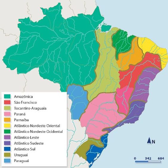 |
| And each region received a great amount of rivers and life-giving water: the river basins - Map 4 (Compare this map to this) |
The Rivers
Map 4 shows the river basins of Brazil. Again the Amazon Jungle area stands out as also being the country's number one river basin. In it you will find huge Amazonian Rivers like the Amazon River itself, the Javari, the Putumayo/Iça, the Caquetá/Japurá, the Meta / Rio Negro, the Juruá and the complex life-giving system of tributaries in the area that floods for six months. Bordering on the Amazon Baisin we have the Paraguay River Basin which flows into the Pantanal Area going down into Paraguay and as far as Argentina where it will meet the Paraná River, the 12th largerst in the world. Very important and still unknown to the majority of Earthians is the green-colored area bordering on the Amazon Basin and flowing into it. It is the Tocantins-Araguaia River Basin. Tocantins is a river of its own as is the Araguaia. This is a very beautiful, dream-like area full of undescribable natural beauties and attractions that we will show you in later more detailed posts. Two other larger basins are the Paraná Basin, pink on the map, that collects water from the lower half of Brazil.
Brasilia, the Capital of the Country, sits not far from a Biological Reservation called "Águas Emendadas" or Blended Waters. Waters that spring up from the ground merely meters apart will travel to help engross two of the most imortant riverbasins in Suth America: Amazon and Paraná. Iguassu Falls, located 20 kilometers before the Iguazú (Iguaçu, Iguassu) River flows into the Paraná River is a member of this basin.
 |
| Administrative human areas called "states" were created: 26 were created. Brasília the capital in the Cerrado Biome has the status of a state under the name of Distrito Federal (DF) between GO and MG - Map 5 |
With map 5 we want
to give you an Idea of Brazil’s internal divisions as far as states are concerned.
There are no names or identifications in the spaces representing the states.
That mission will be fulfilled with map 6. All spaces occupied by states have
received the abbreviations of their names. Beginning with the all important
Amazon JUNGLE biome we have the states of Amazonas (AM), Roraima (RR), Amapá (AP), Pará
(PA), Mato Grosso (MT, not totally in the Amazon Area), Rondônia (RO) and Acre
(AC). In the Cerrado Savana Area we have states or part of some states in this important
ecoregion mainly Tocantins (TO), Goiás (GO), Mato Grosso (MT), Mato Grosso do
Sul (MS), also covering parts of Bahia (BA),Minas Gerais (MG), São Paulo (SP)
and even Paraná (PR). In the Atlantic Forest Area proper we may
include parts of Maranhão (MA),Piauí (PI), Ceará (CE), Rio Grande do Norte (RN),
Paraíba (PB), Pernambuco (PE), Alagoas (AL), Sergipe (SE), Bahia (BA), Espirito
Santo (ES), Rio de Janeiro (RJ) and happily São Paulo (SP), Paraná (PR), Santa Catarina (SC) and Rio Grande do Sul
(RS).
Over 1.8 million hectars of
preserved Atlantic Forest is to be found along the Rio de Janeiro – Santa Catarina
stretch with more important reserves inland in São Paulo and the area between the
coastal cities and sea ports of Paranaguá and Antonina, Curitiba (PR) and
the Iguassu National Park on the border with Argentina. The Itajaí River Valley
in Santa Catarina is also rich in Atlantic Forests preserves. Two things are important to highlight: borders of biomes do not always correspond to latter-day man-drawn state lines. Some travelers assume that traveling in Brazil may be boring because landscapes may be the same for hours. I hope this posts offer a hint to planning your adventures naturally.
 |
| And then these states were given names. Two-letter abreviations were adopted to identifiy these states - Map 6 |
| Ju |
When Brazilians try
to understand their country they will possibly think in terms of five regions.
North, Northeast, Central West, Southeast and South. The North and Northeast are
economically more depressed than the Southeast and South. São Paulo and Rio de
Janeiro are in the Southeast. Curitiba and Porto Alegre are in the South.
Salvador, Recife, Maceió are in the Northeast and Manaus, Belém and Macapá are in the North. We will
dive deeper in all these regions in our next posts, videos, trips and expeditions.
 |
| The 27 states house 5.570 municipalities (cities) - Map 7 |
Now we welcome you
to the map of Brazil as it is with all the states, their main cities and other
observations. Down to earth matters as airplanes, airports, flight planning,
consulates, governments seats are organized according to this map. The state of
Paraná, where this blog and blogger live, has 399 cities or municipalities.
Politicians have been working very hard trying to prevent the creation of one
more city that would reach the tipping point that would be having 400. It is psychological:
399 and is better than 400. The federal government is proposing to cancel the
existence of all cities with less than 5,000 thousand inhabitants and try to
merge two or more into a larger one. Nobody wants that.
Finally please note that there is a blue line following the coastline showing the Brazilian 200-mile offshore limit including areas around Brazilian Atlantic Ocean islands, The Brazilian Navy calls this area Blue Amazonia. The Island of Fernando de Noronha is present on the wishlist of 9 out of 10 Brazilians.
No comments:
Post a Comment